


thoraise

MartinBraudThierry
User
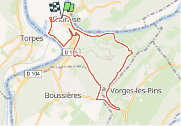

Length
9.9 km

Max alt
366 m

Uphill gradient
211 m
Km-Effort
12.7 km

Min alt
223 m

Downhill gradient
211 m
Boucle
Yes
Creation date :
2023-04-20 06:59:49.184
Updated on :
2023-04-20 09:50:19.95
2h50
Difficulty : Difficult

FREE GPS app for hiking
 SityTrail
IGN / Geographical institutes
SityTrail Plus
The world is yours!
About
Trail Walking of 9.9 km to be discovered at Bourgogne-Franche-Comté, Doubs, Thoraise. This trail is proposed by MartinBraudThierry.
Positioning
Country:
France
Region :
Bourgogne-Franche-Comté
Department/Province :
Doubs
Municipality :
Thoraise
Location:
Unknown
Start:(Dec)
Start:(UTM)
719928 ; 5228629 (31T) N.
Comments