


Rambouillet Epernon

taguette
User
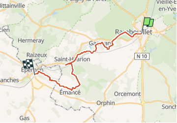

Length
22 km

Max alt
172 m

Uphill gradient
230 m
Km-Effort
25 km

Min alt
115 m

Downhill gradient
269 m
Boucle
No
Creation date :
2023-04-20 07:36:33.69
Updated on :
2023-04-20 12:50:30.44
5h10
Difficulty : Very difficult

FREE GPS app for hiking
 SityTrail
IGN / Geographical institutes
SityTrail Plus
The world is yours!
About
Trail Walking of 22 km to be discovered at Ile-de-France, Yvelines, Rambouillet. This trail is proposed by taguette.
Positioning
Country:
France
Region :
Ile-de-France
Department/Province :
Yvelines
Municipality :
Rambouillet
Location:
Unknown
Start:(Dec)
Start:(UTM)
413892 ; 5388495 (31U) N.
Comments