


sporti

VANDERPUTTENMi
User GUIDE
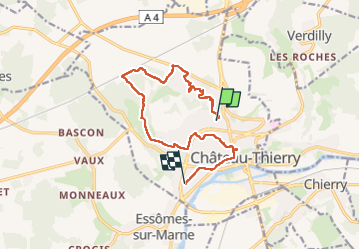

Length
12.1 km

Max alt
222 m

Uphill gradient
173 m
Km-Effort
14.5 km

Min alt
62 m

Downhill gradient
221 m
Boucle
No
Creation date :
2023-04-21 07:23:13.409
Updated on :
2023-04-21 12:15:19.973
4h10
Difficulty : Difficult

FREE GPS app for hiking
 SityTrail
IGN / Geographical institutes
SityTrail Plus
The world is yours!
About
Trail Walking of 12.1 km to be discovered at Hauts-de-France, Aisne, Château-Thierry. This trail is proposed by VANDERPUTTENMi.
Positioning
Country:
France
Region :
Hauts-de-France
Department/Province :
Aisne
Municipality :
Château-Thierry
Location:
Unknown
Start:(Dec)
Start:(UTM)
528693 ; 5433563 (31U) N.
Comments