


Valence Centre ville

MAUVAGE Patrick
User
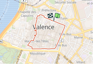

Length
1.7 km

Max alt
138 m

Uphill gradient
12 m
Km-Effort
1.9 km

Min alt
127 m

Downhill gradient
15 m
Boucle
Yes
Creation date :
2023-04-21 13:58:50.0
Updated on :
2023-04-21 18:42:42.193
25m
Difficulty : Easy

FREE GPS app for hiking
 SityTrail
IGN / Geographical institutes
SityTrail Plus
The world is yours!
About
Trail Walking of 1.7 km to be discovered at Auvergne-Rhône-Alpes, Drôme, Valence. This trail is proposed by MAUVAGE Patrick.
Positioning
Country:
France
Region :
Auvergne-Rhône-Alpes
Department/Province :
Drôme
Municipality :
Valence
Location:
Unknown
Start:(Dec)
Start:(UTM)
649435 ; 4977353 (31T) N.
Comments