


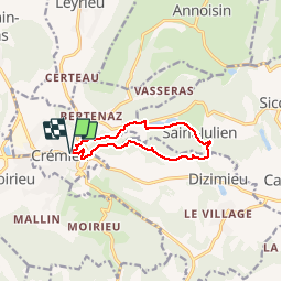
Crémieu

florent43
User

Length
9.2 km

Max alt
407 m

Uphill gradient
252 m
Km-Effort
12.6 km

Min alt
220 m

Downhill gradient
252 m
Boucle
Yes
Creation date :
2014-12-10 00:00:00.0
Updated on :
2014-12-10 00:00:00.0
2h39
Difficulty : Easy

FREE GPS app for hiking
 SityTrail
IGN / Geographical institutes
SityTrail Plus
The world is yours!
About
Trail Walking of 9.2 km to be discovered at Auvergne-Rhône-Alpes, Isère, Crémieu. This trail is proposed by florent43.
Positioning
Country:
France
Region :
Auvergne-Rhône-Alpes
Department/Province :
Isère
Municipality :
Crémieu
Location:
Unknown
Start:(Dec)
Start:(UTM)
675169 ; 5065930 (31T) N.
Comments