


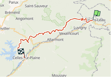
Étape 5 de la balade du chien en Alsace /Meurthe-et-Moselle /Vosges

Regisconraud
User

Length
26 km

Max alt
718 m

Uphill gradient
825 m
Km-Effort
37 km

Min alt
310 m

Downhill gradient
943 m
Boucle
No
Creation date :
2023-04-21 06:23:22.849
Updated on :
2023-04-21 16:31:01.649
10h04
Difficulty : Very difficult

FREE GPS app for hiking
 SityTrail
IGN / Geographical institutes
SityTrail Plus
The world is yours!
About
Trail Walking of 26 km to be discovered at Grand Est, Meurthe-et-Moselle, Raon-lès-Leau. This trail is proposed by Regisconraud.
Positioning
Country:
France
Region :
Grand Est
Department/Province :
Meurthe-et-Moselle
Municipality :
Raon-lès-Leau
Location:
Unknown
Start:(Dec)
Start:(UTM)
359646 ; 5374994 (32U) N.
Comments