


étude rochegude - uchaux

mapomme
User
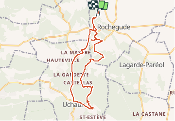

Length
18.1 km

Max alt
278 m

Uphill gradient
330 m
Km-Effort
23 km

Min alt
85 m

Downhill gradient
342 m
Boucle
No
Creation date :
2014-12-10 00:00:00.0
Updated on :
2014-12-10 00:00:00.0
2h25
Difficulty : Easy

FREE GPS app for hiking
 SityTrail
IGN / Geographical institutes
SityTrail Plus
The world is yours!
About
Trail Walking of 18.1 km to be discovered at Auvergne-Rhône-Alpes, Drôme, Rochegude. This trail is proposed by mapomme.
Description
Moitié VTT moitié goudron... Ballade prospective ...


Positioning
Country:
France
Region :
Auvergne-Rhône-Alpes
Department/Province :
Drôme
Municipality :
Rochegude
Location:
Unknown
Start:(Dec)
Start:(UTM)
645116 ; 4901718 (31T) N.
Comments