


Paris - Lacs de Pétarel (1)

Danielba
User GUIDE
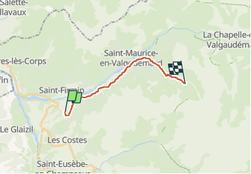

Length
13.9 km

Max alt
1596 m

Uphill gradient
877 m
Km-Effort
24 km

Min alt
906 m

Downhill gradient
262 m
Boucle
No
Creation date :
2023-04-22 14:01:33.868
Updated on :
2023-04-22 14:23:06.116
5h20
Difficulty : Very difficult

FREE GPS app for hiking
 SityTrail
IGN / Geographical institutes
SityTrail Plus
The world is yours!
About
Trail Walking of 13.9 km to be discovered at Provence-Alpes-Côte d'Azur, Hautes-Alpes, Saint-Jacques-en-Valgodemard. This trail is proposed by Danielba .
Positioning
Country:
France
Region :
Provence-Alpes-Côte d'Azur
Department/Province :
Hautes-Alpes
Municipality :
Saint-Jacques-en-Valgodemard
Location:
Unknown
Start:(Dec)
Start:(UTM)
265080 ; 4961209 (32T) N.
Comments