


Cabane Sellar (2e jour)

Danielba
User GUIDE
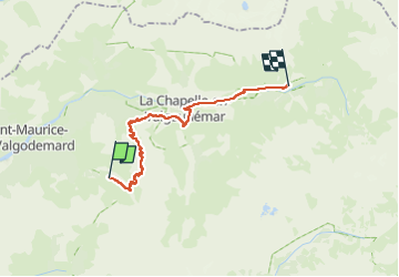

Length
19.8 km

Max alt
2428 m

Uphill gradient
1206 m
Km-Effort
36 km

Min alt
1097 m

Downhill gradient
1383 m
Boucle
No
Creation date :
2023-04-22 14:31:43.277
Updated on :
2023-04-22 14:34:28.12
8h17
Difficulty : Very difficult

FREE GPS app for hiking
 SityTrail
IGN / Geographical institutes
SityTrail Plus
The world is yours!
About
Trail Walking of 19.8 km to be discovered at Provence-Alpes-Côte d'Azur, Hautes-Alpes, Saint-Maurice-en-Valgodemard. This trail is proposed by Danielba .
Positioning
Country:
France
Region :
Provence-Alpes-Côte d'Azur
Department/Province :
Hautes-Alpes
Municipality :
Saint-Maurice-en-Valgodemard
Location:
Unknown
Start:(Dec)
Start:(UTM)
274471 ; 4963131 (32T) N.
Comments