


Refuge Vallonpierre Refuge Pré Chaumette

Danielba
User GUIDE
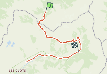

Length
22 km

Max alt
2667 m

Uphill gradient
1100 m
Km-Effort
38 km

Min alt
1465 m

Downhill gradient
1584 m
Boucle
No
Creation date :
2023-04-22 15:05:10.654
Updated on :
2023-04-22 15:07:04.575
8h44
Difficulty : Very difficult

FREE GPS app for hiking
 SityTrail
IGN / Geographical institutes
SityTrail Plus
The world is yours!
About
Trail Walking of 22 km to be discovered at Provence-Alpes-Côte d'Azur, Hautes-Alpes, La Chapelle-en-Valgaudémar. This trail is proposed by Danielba .
Positioning
Country:
France
Region :
Provence-Alpes-Côte d'Azur
Department/Province :
Hautes-Alpes
Municipality :
La Chapelle-en-Valgaudémar
Location:
Unknown
Start:(Dec)
Start:(UTM)
285580 ; 4964135 (32T) N.
Comments