


Gy 20230420

cmike39
User
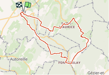

Length
21 km

Max alt
385 m

Uphill gradient
593 m
Km-Effort
29 km

Min alt
231 m

Downhill gradient
593 m
Boucle
Yes
Creation date :
2023-04-20 06:43:10.783
Updated on :
2023-04-23 10:02:58.563
5h09
Difficulty : Very difficult

FREE GPS app for hiking
 SityTrail
IGN / Geographical institutes
SityTrail Plus
The world is yours!
About
Trail Walking of 21 km to be discovered at Bourgogne-Franche-Comté, Haute-Saône, Gy. This trail is proposed by cmike39.
Positioning
Country:
France
Region :
Bourgogne-Franche-Comté
Department/Province :
Haute-Saône
Municipality :
Gy
Location:
Unknown
Start:(Dec)
Start:(UTM)
712367 ; 5254210 (31T) N.
Comments