


tour ville les ifs

RoMo
User
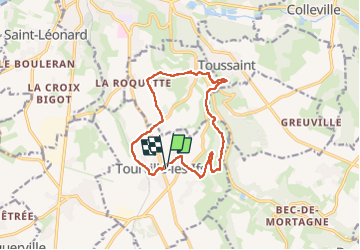

Length
12.1 km

Max alt
128 m

Uphill gradient
224 m
Km-Effort
15.1 km

Min alt
27 m

Downhill gradient
224 m
Boucle
Yes
Creation date :
2023-04-23 07:00:23.359
Updated on :
2023-04-23 10:43:21.501
2h55
Difficulty : Medium

FREE GPS app for hiking
 SityTrail
IGN / Geographical institutes
SityTrail Plus
The world is yours!
About
Trail Walking of 12.1 km to be discovered at Normandy, Seine-Maritime, Tourville-les-Ifs. This trail is proposed by RoMo.
Description
boucle
Positioning
Country:
France
Region :
Normandy
Department/Province :
Seine-Maritime
Municipality :
Tourville-les-Ifs
Location:
Unknown
Start:(Dec)
Start:(UTM)
312702 ; 5510091 (31U) N.
Comments