


Mirabel 11km den367m

ganinette
User
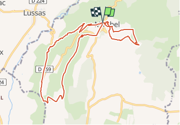

Length
10.8 km

Max alt
534 m

Uphill gradient
367 m
Km-Effort
15.6 km

Min alt
296 m

Downhill gradient
358 m
Boucle
Yes
Creation date :
2023-04-24 06:14:14.585
Updated on :
2024-12-24 08:04:08.072
3h33
Difficulty : Medium

FREE GPS app for hiking
 SityTrail
IGN / Geographical institutes
SityTrail Plus
The world is yours!
About
Trail Walking of 10.8 km to be discovered at Auvergne-Rhône-Alpes, Ardèche, Mirabel. This trail is proposed by ganinette.
Description
1. la grotte (boucle)
2.centre village
3.la tour (pique-nique)
4.rando(boucle)
Photos


Positioning
Country:
France
Region :
Auvergne-Rhône-Alpes
Department/Province :
Ardèche
Municipality :
Mirabel
Location:
Unknown
Start:(Dec)
Start:(UTM)
618751 ; 4940603 (31T) N.
Comments