


crête de Ramiat

aldaus
User
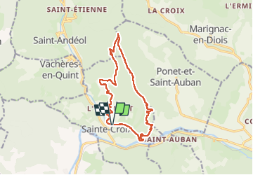

Length
15.3 km

Max alt
977 m

Uphill gradient
726 m
Km-Effort
25 km

Min alt
360 m

Downhill gradient
724 m
Boucle
Yes
Creation date :
2023-04-24 08:46:37.282
Updated on :
2023-04-24 15:30:22.402
5h35
Difficulty : Medium

FREE GPS app for hiking
 SityTrail
IGN / Geographical institutes
SityTrail Plus
The world is yours!
About
Trail Walking of 15.3 km to be discovered at Auvergne-Rhône-Alpes, Drôme, Sainte-Croix. This trail is proposed by aldaus.
Positioning
Country:
France
Region :
Auvergne-Rhône-Alpes
Department/Province :
Drôme
Municipality :
Sainte-Croix
Location:
Unknown
Start:(Dec)
Start:(UTM)
680869 ; 4959968 (31T) N.
Comments