


châteaufort St gêniez ravin de basse terre

Danielba
User GUIDE
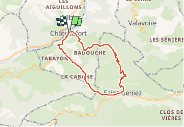

Length
15.1 km

Max alt
1213 m

Uphill gradient
707 m
Km-Effort
25 km

Min alt
586 m

Downhill gradient
709 m
Boucle
Yes
Creation date :
2023-04-25 06:52:15.535
Updated on :
2023-04-25 16:31:51.87
5h34
Difficulty : Very difficult

FREE GPS app for hiking
 SityTrail
IGN / Geographical institutes
SityTrail Plus
The world is yours!
About
Trail Walking of 15.1 km to be discovered at Provence-Alpes-Côte d'Azur, Alpes-de-Haute-Provence, Châteaufort. This trail is proposed by Danielba .
Photos

Positioning
Country:
France
Region :
Provence-Alpes-Côte d'Azur
Department/Province :
Alpes-de-Haute-Provence
Municipality :
Châteaufort
Location:
Unknown
Start:(Dec)
Start:(UTM)
261977 ; 4906684 (32T) N.
Comments