


Valerne vers le pied de Gache

PatriceCocuaud
User
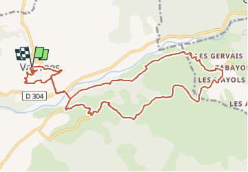

Length
13 km

Max alt
686 m

Uphill gradient
306 m
Km-Effort
17.1 km

Min alt
521 m

Downhill gradient
306 m
Boucle
Yes
Creation date :
2023-04-25 14:52:14.219
Updated on :
2023-04-25 16:55:15.794
1h47
Difficulty : Medium

FREE GPS app for hiking
 SityTrail
IGN / Geographical institutes
SityTrail Plus
The world is yours!
About
Trail Mountain bike of 13 km to be discovered at Provence-Alpes-Côte d'Azur, Alpes-de-Haute-Provence, Valernes. This trail is proposed by PatriceCocuaud.
Positioning
Country:
France
Region :
Provence-Alpes-Côte d'Azur
Department/Province :
Alpes-de-Haute-Provence
Municipality :
Valernes
Location:
Unknown
Start:(Dec)
Start:(UTM)
736045 ; 4905215 (31T) N.
Comments