


MU P23 -V2- Boucle Tête du Bostand

rsedtghijo
User

Length
36 km

Max alt
2376 m

Uphill gradient
2513 m
Km-Effort
69 km

Min alt
687 m

Downhill gradient
2511 m
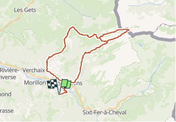
Boucle
Yes
Creation date :
2023-04-25 17:04:31.93
Updated on :
2023-04-26 18:57:59.629
15h45
Difficulty : Very difficult

FREE GPS app for hiking
 SityTrail
IGN / Geographical institutes
SityTrail Plus
The world is yours!
About
Trail Walking of 36 km to be discovered at Auvergne-Rhône-Alpes, Upper Savoy, Samoëns. This trail is proposed by rsedtghijo.
Description
Nuit au refuge de Bostand
Positioning
Country:
France
Region :
Auvergne-Rhône-Alpes
Department/Province :
Upper Savoy
Municipality :
Samoëns
Location:
Unknown
Start:(Dec)
Start:(UTM)
323052 ; 5104537 (32T) N.
Comments