


G1/2- Vif Echaillon

lionelnottat
User
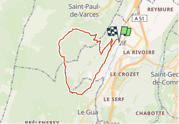

Length
14.6 km

Max alt
807 m

Uphill gradient
836 m
Km-Effort
26 km

Min alt
310 m

Downhill gradient
836 m
Boucle
Yes
Creation date :
2023-04-26 07:38:30.235
Updated on :
2023-04-26 07:39:09.689
5h50
Difficulty : Very difficult

FREE GPS app for hiking
 SityTrail
IGN / Geographical institutes
SityTrail Plus
The world is yours!
About
Trail Walking of 14.6 km to be discovered at Auvergne-Rhône-Alpes, Isère, Vif. This trail is proposed by lionelnottat.
Positioning
Country:
France
Region :
Auvergne-Rhône-Alpes
Department/Province :
Isère
Municipality :
Vif
Location:
Unknown
Start:(Dec)
Start:(UTM)
709986 ; 4992595 (31T) N.
Comments