


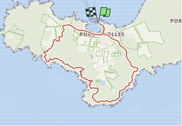
Porquerolles + 233

claude nier
User

Length
9.7 km

Max alt
97 m

Uphill gradient
233 m
Km-Effort
12.8 km

Min alt
-1 m

Downhill gradient
233 m
Boucle
Yes
Creation date :
2023-04-26 16:17:28.691
Updated on :
2023-04-26 16:18:50.288
2h55
Difficulty : Difficult

FREE GPS app for hiking
 SityTrail
IGN / Geographical institutes
SityTrail Plus
The world is yours!
About
Trail Walking of 9.7 km to be discovered at Provence-Alpes-Côte d'Azur, Var, Hyères. This trail is proposed by claude nier.
Description
petite rando sympa
pas trop de monde et de velos
Positioning
Country:
France
Region :
Provence-Alpes-Côte d'Azur
Department/Province :
Var
Municipality :
Hyères
Location:
Unknown
Start:(Dec)
Start:(UTM)
271863 ; 4764927 (32T) N.
Comments