


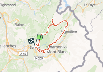
Tour des Aiguilles Rouges

attitude73
User

Length
58 km

Max alt
3083 m

Uphill gradient
4313 m
Km-Effort
116 km

Min alt
816 m

Downhill gradient
4489 m
Boucle
No
Creation date :
2023-04-26 17:48:19.326
Updated on :
2023-04-26 19:30:58.907
26h25
Difficulty : Very difficult

FREE GPS app for hiking
 SityTrail
IGN / Geographical institutes
SityTrail Plus
The world is yours!
About
Trail Walking of 58 km to be discovered at Auvergne-Rhône-Alpes, Upper Savoy, Servoz. This trail is proposed by attitude73.
Points of interest


Positioning
Country:
France
Region :
Auvergne-Rhône-Alpes
Department/Province :
Upper Savoy
Municipality :
Servoz
Location:
Unknown
Start:(Dec)
Start:(UTM)
327269 ; 5090157 (32T) N.
Comments