


PANORAMA MALATRA VERSION 2

clintest
User
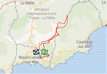

Length
16 km

Max alt
524 m

Uphill gradient
679 m
Km-Effort
25 km

Min alt
89 m

Downhill gradient
682 m
Boucle
Yes
Creation date :
2023-04-26 17:52:24.885
Updated on :
2023-04-26 17:52:55.396
5h41
Difficulty : Medium

FREE GPS app for hiking
 SityTrail
IGN / Geographical institutes
SityTrail Plus
The world is yours!
About
Trail On foot of 16 km to be discovered at Provence-Alpes-Côte d'Azur, Var, Rayol-Canadel-sur-Mer. This trail is proposed by clintest.
Positioning
Country:
France
Region :
Provence-Alpes-Côte d'Azur
Department/Province :
Var
Municipality :
Rayol-Canadel-sur-Mer
Location:
Unknown
Start:(Dec)
Start:(UTM)
295170 ; 4781653 (32T) N.
Comments