


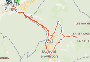
gorges du Nan et cascade de la Gerlette

bymarc26
User

Length
15.5 km

Max alt
1000 m

Uphill gradient
1164 m
Km-Effort
31 km

Min alt
278 m

Downhill gradient
1164 m
Boucle
Yes
Creation date :
2023-04-27 06:48:59.024
Updated on :
2023-04-27 13:30:48.8
4h46
Difficulty : Medium

FREE GPS app for hiking
 SityTrail
IGN / Geographical institutes
SityTrail Plus
The world is yours!
About
Trail Walking of 15.5 km to be discovered at Auvergne-Rhône-Alpes, Isère, Cognin-les-Gorges. This trail is proposed by bymarc26.
Positioning
Country:
France
Region :
Auvergne-Rhône-Alpes
Department/Province :
Isère
Municipality :
Cognin-les-Gorges
Location:
Unknown
Start:(Dec)
Start:(UTM)
689598 ; 5004752 (31T) N.
Comments