


GORGÉS DU NAN

nordan
User

Length
16.7 km

Max alt
1004 m

Uphill gradient
1261 m
Km-Effort
34 km

Min alt
277 m

Downhill gradient
1260 m
Boucle
Yes
Creation date :
2023-04-27 07:53:49.548
Updated on :
2023-04-27 13:56:04.995
4h39
Difficulty : Very difficult

FREE GPS app for hiking
 SityTrail
IGN / Geographical institutes
SityTrail Plus
The world is yours!
About
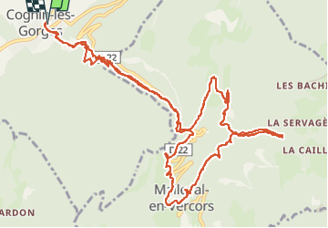
Trail Walking of 16.7 km to be discovered at Auvergne-Rhône-Alpes, Isère, Cognin-les-Gorges. This trail is proposed by nordan.
Positioning
Country:
France
Region :
Auvergne-Rhône-Alpes
Department/Province :
Isère
Municipality :
Cognin-les-Gorges
Location:
Unknown
Start:(Dec)
Start:(UTM)
689573 ; 5004750 (31T) N.
Comments