


GR58 Jour n°4

dudu79
User
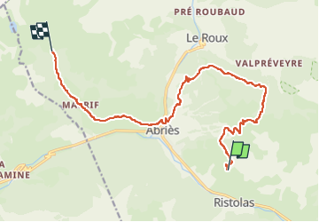

Length
15.5 km

Max alt
2371 m

Uphill gradient
965 m
Km-Effort
28 km

Min alt
1556 m

Downhill gradient
850 m
Boucle
No
Creation date :
2023-04-28 07:53:30.69
Updated on :
2023-04-28 07:55:12.642
6h21
Difficulty : Very difficult

FREE GPS app for hiking
 SityTrail
IGN / Geographical institutes
SityTrail Plus
The world is yours!
About
Trail Walking of 15.5 km to be discovered at Provence-Alpes-Côte d'Azur, Hautes-Alpes, Abriès-Ristolas. This trail is proposed by dudu79.
Positioning
Country:
France
Region :
Provence-Alpes-Côte d'Azur
Department/Province :
Hautes-Alpes
Municipality :
Abriès-Ristolas
Location:
Unknown
Start:(Dec)
Start:(UTM)
338070 ; 4960872 (32T) N.
Comments