


GR58 Jour n°5

dudu79
User
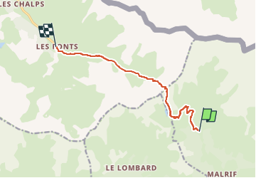

Length
9.5 km

Max alt
2815 m

Uphill gradient
776 m
Km-Effort
19.8 km

Min alt
2040 m

Downhill gradient
765 m
Boucle
No
Creation date :
2023-04-28 07:58:53.577
Updated on :
2023-04-28 07:59:33.574
4h30
Difficulty : Very difficult

FREE GPS app for hiking
 SityTrail
IGN / Geographical institutes
SityTrail Plus
The world is yours!
About
Trail Walking of 9.5 km to be discovered at Provence-Alpes-Côte d'Azur, Hautes-Alpes, Abriès-Ristolas. This trail is proposed by dudu79.
Positioning
Country:
France
Region :
Provence-Alpes-Côte d'Azur
Department/Province :
Hautes-Alpes
Municipality :
Abriès-Ristolas
Location:
Abriès
Start:(Dec)
Start:(UTM)
332788 ; 4964636 (32T) N.
Comments