


GR58 Jour n° 6

dudu79
User
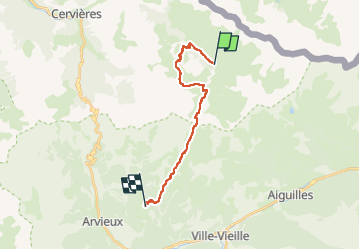

Length
17.2 km

Max alt
2633 m

Uphill gradient
1105 m
Km-Effort
33 km

Min alt
1844 m

Downhill gradient
1310 m
Boucle
No
Creation date :
2023-04-28 08:05:26.052
Updated on :
2023-04-28 09:20:56.61
7h24
Difficulty : Very difficult

FREE GPS app for hiking
 SityTrail
IGN / Geographical institutes
SityTrail Plus
The world is yours!
About
Trail Walking of 17.2 km to be discovered at Provence-Alpes-Côte d'Azur, Hautes-Alpes, Cervières. This trail is proposed by dudu79.
Description
raccourcir de 6.3km et 492D et 495D- en évitant la variante GR58 au départ des fonds de Cervière.
Positioning
Country:
France
Region :
Provence-Alpes-Côte d'Azur
Department/Province :
Hautes-Alpes
Municipality :
Cervières
Location:
Unknown
Start:(Dec)
Start:(UTM)
327403 ; 4968013 (32T) N.
Comments