


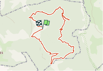
Boucle à partir de l'Abbaye de Valcroissant (Die)

Clo0413
User

Length
13 km

Max alt
1084 m

Uphill gradient
654 m
Km-Effort
22 km

Min alt
599 m

Downhill gradient
657 m
Boucle
Yes
Creation date :
2023-04-28 08:42:28.367
Updated on :
2023-05-03 17:31:14.94
3h57
Difficulty : Medium

FREE GPS app for hiking
 SityTrail
IGN / Geographical institutes
SityTrail Plus
The world is yours!
About
Trail Walking of 13 km to be discovered at Auvergne-Rhône-Alpes, Drôme, Die. This trail is proposed by Clo0413.
Positioning
Country:
France
Region :
Auvergne-Rhône-Alpes
Department/Province :
Drôme
Municipality :
Die
Location:
Unknown
Start:(Dec)
Start:(UTM)
692567 ; 4957563 (31T) N.
Comments