


Le Reculet et Crêt de la Neige

i20
User
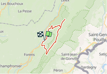

Length
20 km

Max alt
1707 m

Uphill gradient
1309 m
Km-Effort
37 km

Min alt
694 m

Downhill gradient
1306 m
Boucle
Yes
Creation date :
2023-04-28 20:05:58.414
Updated on :
2023-04-28 20:09:00.913
8h30
Difficulty : Very difficult

FREE GPS app for hiking
 SityTrail
IGN / Geographical institutes
SityTrail Plus
The world is yours!
About
Trail Walking of 20 km to be discovered at Auvergne-Rhône-Alpes, Ain, Chézery-Forens. This trail is proposed by i20.
Positioning
Country:
France
Region :
Auvergne-Rhône-Alpes
Department/Province :
Ain
Municipality :
Chézery-Forens
Location:
Unknown
Start:(Dec)
Start:(UTM)
723049 ; 5124442 (31T) N.
Comments