


Tour des 4 lacs - Pic de l'Aigle

i20
User
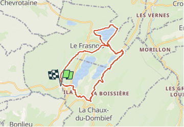

Length
15.1 km

Max alt
991 m

Uphill gradient
382 m
Km-Effort
20 km

Min alt
748 m

Downhill gradient
383 m
Boucle
Yes
Creation date :
2023-04-28 20:35:36.93
Updated on :
2023-04-28 20:36:02.323
4h34
Difficulty : Very difficult

FREE GPS app for hiking
 SityTrail
IGN / Geographical institutes
SityTrail Plus
The world is yours!
About
Trail Walking of 15.1 km to be discovered at Bourgogne-Franche-Comté, Jura, Le Frasnois. This trail is proposed by i20.
Positioning
Country:
France
Region :
Bourgogne-Franche-Comté
Department/Province :
Jura
Municipality :
Le Frasnois
Location:
Unknown
Start:(Dec)
Start:(UTM)
720619 ; 5166768 (31T) N.
Comments