Trail Walking Utelle - Le Chaudan Madone Utelle réel - Photo

Le Chaudan Madone Utelle réel

 jouans
jouans

User

© OpenStreetMap contributors
Length
Length
19.6 km
Max alt
Max alt
1188 m
Uphill gradient
Uphill gradient
1287 m
Km-Effort
Km-Effort  
37 km
Min alt
Min alt
173 m
Downhill gradient
Downhill gradient
1291 m
Boucle
Boucle
Yes
Creation date :
2023-04-29 06:06:12.0
Updated on :
2023-04-30 06:23:32.409

(0 Reviews)

Walking
Walking
5h55
Difficulty : Very difficult

Scan this QR Code to open this trail in the SityTrail application

FREE GPS app for hiking

Logo SityTrail SityTrail

IGN / Geographical institutes

Download SityTrail from the App Store Download SityTrail from Google Play

Logo SityTrail SityTrail World

The world is yours!

Download SityTrail from the App Store Download SityTrail from Google Play Download SityTrail on Huawei AppGallery

About

Trail Walking of 19.6 km to be discovered at Provence-Alpes-Côte d'Azur, Maritime Alps, Utelle. This trail is proposed by jouans.

Description

Chaudan cols de Moutête Ambellarte Madone Utelle les Antennes Ambellarte Vallon Signora La Villette Les Pylônes Le Chaudan
Rando faite le 29/4/2023 Annie TM JJ

Elevation profile

Photos

Positioning

Country:
France
Region :
Provence-Alpes-Côte d'Azur
Department/Province :
Maritime Alps
Municipality :
Utelle
Location:
Unknown
Start:(UTM)
355218 ; 4859140 (32T) N.

Trails nearby

Trail On foot Utelle - Gorges de la Vésubie - Photo
On foot
PRO

On foot

Medium
(1)
Utelle, Provence-Alpes-Côte d'Azur, Maritime Alps, France
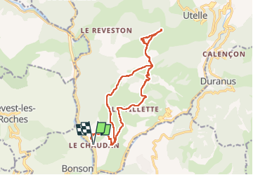
14.6 km | 27 km-effort
6h 11min
Yes
Trail On foot Utelle - Madone d'Utelle - Photo
On foot
PRO

On foot

Easy
Utelle, Provence-Alpes-Côte d'Azur, Maritime Alps, France
9.9 km | 19.4 km-effort
4h 24min
Yes
Trail On foot Gilette - Tour du mont Lion - Photo
On foot
PRO

On foot

Medium
Gilette, Provence-Alpes-Côte d'Azur, Maritime Alps, France
13.4 km | 25 km-effort
5h 44min
Yes
Trail Walking Levens - Hike 2017 jour 1 - Photo
Walking
albert318

Walking

Very difficult
(1)
Levens, Provence-Alpes-Côte d'Azur, Maritime Alps, France
14.7 km | 29 km-effort
6h 27min
No
Trail Walking Bonson - Plan du Var-Tourrette du Château  - Photo
Walking
ETMU5496

Walking

Difficult
Bonson, Provence-Alpes-Côte d'Azur, Maritime Alps, France
19.1 km | 35 km-effort
7h 50min
Yes
Trail Walking Le Broc - Le Broc-Bouyon fait - Photo
Walking
ETMU5496

Walking

Difficult
Le Broc, Provence-Alpes-Côte d'Azur, Maritime Alps, France
19.1 km | 31 km-effort
7h 0min
Yes
Trail Walking Revest-les-Roches - Balme de Vial - Photo
Walking
56jj

Walking

Medium
Revest-les-Roches, Provence-Alpes-Côte d'Azur, Maritime Alps, France
7.4 km | 14.6 km-effort
5h 1min
No
Trail Walking Utelle - Cros d Utelle chapelle St Antoine - Photo
Walking
56jj

Walking

Difficult
Utelle, Provence-Alpes-Côte d'Azur, Maritime Alps, France
7.5 km | 13.7 km-effort
4h 6min
Yes
Trail Walking Gilette - Gilette - Pont de la Cerise - Photo
Walking
LtZIP

Walking

Medium
Gilette, Provence-Alpes-Côte d'Azur, Maritime Alps, France
17.2 km | 30 km-effort
4h 29min
Yes


Close
My subscriptions