


Compostelle 2023 étape 11 29 avril 2023 Condom - Lamothe

Christianlabourie
User
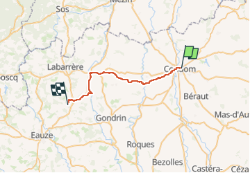

Length
27 km

Max alt
179 m

Uphill gradient
461 m
Km-Effort
33 km

Min alt
72 m

Downhill gradient
386 m
Boucle
No
Creation date :
2023-04-29 06:06:45.189
Updated on :
2023-04-29 13:33:35.916
7h23
Difficulty : Very difficult

FREE GPS app for hiking
 SityTrail
IGN / Geographical institutes
SityTrail Plus
The world is yours!
About
Trail Walking of 27 km to be discovered at Occitania, Gers, Condom. This trail is proposed by Christianlabourie.
Positioning
Country:
France
Region :
Occitania
Department/Province :
Gers
Municipality :
Condom
Location:
Unknown
Start:(Dec)
Start:(UTM)
289685 ; 4870420 (31T) N.
Comments