


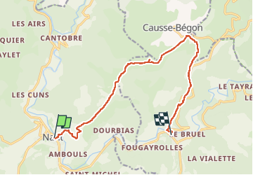
Nant-Causse Begon-St Jean du Bruel

jeff2
User

Length
14 km

Max alt
890 m

Uphill gradient
513 m
Km-Effort
21 km

Min alt
474 m

Downhill gradient
492 m
Boucle
No
Creation date :
2023-04-29 07:09:05.324
Updated on :
2023-04-29 16:00:44.963
8h04
Difficulty : Medium

FREE GPS app for hiking
 SityTrail
IGN / Geographical institutes
SityTrail Plus
The world is yours!
About
Trail Walking of 14 km to be discovered at Occitania, Aveyron, Nant. This trail is proposed by jeff2.
Description
Montée tranquille sous une petite heure de pluie, puis Tombeau du Géant.
Casse croûte sur le Causse Begon.
Arrivée à st Jean du Bruel.
Photos


21 photos in total. Please click on a photo to see them all in the gallery.
Positioning
Country:
France
Region :
Occitania
Department/Province :
Aveyron
Municipality :
Nant
Location:
Unknown
Start:(Dec)
Start:(UTM)
524227 ; 4874404 (31T) N.
Comments