


290423 Tour du Néron

mzonzon05
User

Length
12.3 km

Max alt
761 m

Uphill gradient
667 m
Km-Effort
21 km

Min alt
207 m

Downhill gradient
712 m
Boucle
No
Creation date :
2023-04-29 12:50:02.661
Updated on :
2023-04-29 17:13:14.304
4h22
Difficulty : Very difficult

FREE GPS app for hiking
 SityTrail
IGN / Geographical institutes
SityTrail Plus
The world is yours!
About
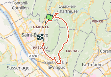
Trail Walking of 12.3 km to be discovered at Auvergne-Rhône-Alpes, Isère, Saint-Égrève. This trail is proposed by mzonzon05.
Description
Joli tour de notre montagne par les anciennes batteries puis Narbone le Canet et SMV.
Terrain varié entre route forestière et sentier de chasseur. quelques très jolis points de vue sur Grenoble.
Photos


Positioning
Country:
France
Region :
Auvergne-Rhône-Alpes
Department/Province :
Isère
Municipality :
Saint-Égrève
Location:
Unknown
Start:(Dec)
Start:(UTM)
711379 ; 5013248 (31T) N.
Comments