


Mandeure

taguette
User
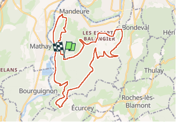

Length
24 km

Max alt
593 m

Uphill gradient
614 m
Km-Effort
32 km

Min alt
330 m

Downhill gradient
613 m
Boucle
Yes
Creation date :
2023-04-29 07:45:11.661
Updated on :
2023-04-30 10:28:01.333
5h44
Difficulty : Difficult

FREE GPS app for hiking
 SityTrail
IGN / Geographical institutes
SityTrail Plus
The world is yours!
About
Trail Walking of 24 km to be discovered at Bourgogne-Franche-Comté, Doubs, Mandeure. This trail is proposed by taguette.
Positioning
Country:
France
Region :
Bourgogne-Franche-Comté
Department/Province :
Doubs
Municipality :
Mandeure
Location:
Unknown
Start:(Dec)
Start:(UTM)
333933 ; 5255314 (32T) N.
Comments