


Auxerre Vézelay

levequejef
User
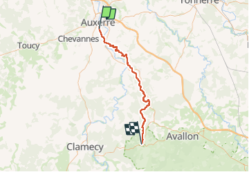

Length
55 km

Max alt
297 m

Uphill gradient
1340 m
Km-Effort
73 km

Min alt
98 m

Downhill gradient
1194 m
Boucle
No
Creation date :
2023-04-30 03:58:30.706
Updated on :
2023-04-30 13:24:29.49
9h19
Difficulty : Difficult

FREE GPS app for hiking
 SityTrail
IGN / Geographical institutes
SityTrail Plus
The world is yours!
About
Trail Walking of 55 km to be discovered at Bourgogne-Franche-Comté, Yonne, Auxerre. This trail is proposed by levequejef.
Positioning
Country:
France
Region :
Bourgogne-Franche-Comté
Department/Province :
Yonne
Municipality :
Auxerre
Location:
Unknown
Start:(Dec)
Start:(UTM)
543296 ; 5292050 (31T) N.
Comments