


Céreste 2-village-Gardette-08-05-2023

Christiancordin
User
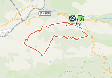

Length
7.7 km

Max alt
533 m

Uphill gradient
253 m
Km-Effort
11.1 km

Min alt
339 m

Downhill gradient
254 m
Boucle
Yes
Creation date :
2023-04-30 15:03:47.766
Updated on :
2023-04-30 15:08:50.583
2h30
Difficulty : Easy

FREE GPS app for hiking
 SityTrail
IGN / Geographical institutes
SityTrail Plus
The world is yours!
About
Trail On foot of 7.7 km to be discovered at Provence-Alpes-Côte d'Azur, Alpes-de-Haute-Provence, Céreste. This trail is proposed by Christiancordin.
Description
Céreste pk face église St Michel-chemin de Merdançon-les Frances-lieu-dit Pradine (champs de lavande)-colline de la Gardette.
Positioning
Country:
France
Region :
Provence-Alpes-Côte d'Azur
Department/Province :
Alpes-de-Haute-Provence
Municipality :
Céreste
Location:
Unknown
Start:(Dec)
Start:(UTM)
708268 ; 4859096 (31T) N.
Comments