


Vachere

darranger
User

Length
20 km

Max alt
848 m

Uphill gradient
591 m
Km-Effort
28 km

Min alt
406 m

Downhill gradient
591 m
Boucle
Yes
Creation date :
2023-05-01 07:41:27.722
Updated on :
2023-05-01 14:00:18.95
6h17
Difficulty : Very difficult

FREE GPS app for hiking
 SityTrail
IGN / Geographical institutes
SityTrail Plus
The world is yours!
About
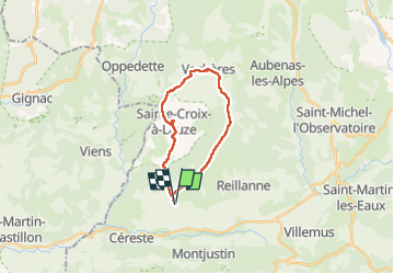
Trail Walking of 20 km to be discovered at Provence-Alpes-Côte d'Azur, Alpes-de-Haute-Provence, Céreste. This trail is proposed by darranger.
Positioning
Country:
France
Region :
Provence-Alpes-Côte d'Azur
Department/Province :
Alpes-de-Haute-Provence
Municipality :
Céreste
Location:
Unknown
Start:(Dec)
Start:(UTM)
710300 ; 4860891 (31T) N.
Comments