


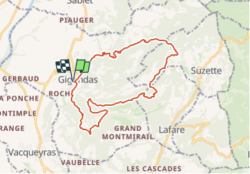
2023-05-02_09h13m39_1682929713244_montmirail 17.7

34christophe
User

Length
17.7 km

Max alt
584 m

Uphill gradient
849 m
Km-Effort
29 km

Min alt
233 m

Downhill gradient
849 m
Boucle
Yes
Creation date :
2023-05-02 07:13:40.064
Updated on :
2023-08-19 16:51:28.719
6h35
Difficulty : Very difficult

FREE GPS app for hiking
 SityTrail
IGN / Geographical institutes
SityTrail Plus
The world is yours!
About
Trail Walking of 17.7 km to be discovered at Provence-Alpes-Côte d'Azur, Vaucluse, Gigondas. This trail is proposed by 34christophe.
Positioning
Country:
France
Region :
Provence-Alpes-Côte d'Azur
Department/Province :
Vaucluse
Municipality :
Gigondas
Location:
Unknown
Start:(Dec)
Start:(UTM)
660137 ; 4891958 (31T) N.
Comments