


2023-05-02 Saulx

Lucquiaud
User
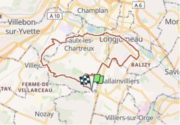

Length
17.6 km

Max alt
167 m

Uphill gradient
262 m
Km-Effort
21 km

Min alt
39 m

Downhill gradient
265 m
Boucle
Yes
Creation date :
2023-05-02 07:22:31.635
Updated on :
2023-05-02 12:05:34.562
4h42
Difficulty : Very difficult

FREE GPS app for hiking
 SityTrail
IGN / Geographical institutes
SityTrail Plus
The world is yours!
About
Trail Walking of 17.6 km to be discovered at Ile-de-France, Essonne, Saulx-les-Chartreux. This trail is proposed by Lucquiaud.
Positioning
Country:
France
Region :
Ile-de-France
Department/Province :
Essonne
Municipality :
Saulx-les-Chartreux
Location:
Unknown
Start:(Dec)
Start:(UTM)
446646 ; 5391119 (31U) N.
Comments