


Pont de Roide

taguette
User
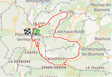

Length
21 km

Max alt
784 m

Uphill gradient
659 m
Km-Effort
30 km

Min alt
345 m

Downhill gradient
659 m
Boucle
Yes
Creation date :
2023-05-02 07:04:01.944
Updated on :
2023-05-02 12:36:02.364
5h10
Difficulty : Difficult

FREE GPS app for hiking
 SityTrail
IGN / Geographical institutes
SityTrail Plus
The world is yours!
About
Trail Walking of 21 km to be discovered at Bourgogne-Franche-Comté, Doubs, Pont-de-Roide-Vermondans. This trail is proposed by taguette.
Positioning
Country:
France
Region :
Bourgogne-Franche-Comté
Department/Province :
Doubs
Municipality :
Pont-de-Roide-Vermondans
Location:
Unknown
Start:(Dec)
Start:(UTM)
331900 ; 5250376 (32T) N.
Comments