


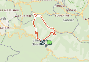
Saint André de Val borgne Château de Pommaret

JMJ42
User

Length
13.6 km

Max alt
930 m

Uphill gradient
569 m
Km-Effort
21 km

Min alt
426 m

Downhill gradient
576 m
Boucle
Yes
Creation date :
2023-05-02 08:01:44.709
Updated on :
2023-05-02 13:52:46.696
3h48
Difficulty : Difficult

FREE GPS app for hiking
 SityTrail
IGN / Geographical institutes
SityTrail Plus
The world is yours!
About
Trail Walking of 13.6 km to be discovered at Occitania, Gard, Saint-André-de-Valborgne. This trail is proposed by JMJ42.
Positioning
Country:
France
Region :
Occitania
Department/Province :
Gard
Municipality :
Saint-André-de-Valborgne
Location:
Unknown
Start:(Dec)
Start:(UTM)
555143 ; 4888767 (31T) N.
Comments