


Saint Hippolyte

taguette
User
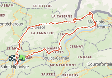

Length
23 km

Max alt
811 m

Uphill gradient
792 m
Km-Effort
34 km

Min alt
370 m

Downhill gradient
795 m
Boucle
Yes
Creation date :
2023-05-03 06:50:58.827
Updated on :
2023-05-03 13:55:27.675
6h42
Difficulty : Difficult

FREE GPS app for hiking
 SityTrail
IGN / Geographical institutes
SityTrail Plus
The world is yours!
About
Trail Walking of 23 km to be discovered at Bourgogne-Franche-Comté, Doubs, Saint-Hippolyte. This trail is proposed by taguette.
Positioning
Country:
France
Region :
Bourgogne-Franche-Comté
Department/Province :
Doubs
Municipality :
Saint-Hippolyte
Location:
Unknown
Start:(Dec)
Start:(UTM)
334928 ; 5242932 (32T) N.
Comments