


Marcel estruche

Danielba
User GUIDE

Length
10.4 km

Max alt
1045 m

Uphill gradient
696 m
Km-Effort
18.9 km

Min alt
681 m

Downhill gradient
451 m
Boucle
No
Creation date :
2023-05-03 05:45:05.147
Updated on :
2023-05-03 16:54:39.011
8h06
Difficulty : Difficult

FREE GPS app for hiking
 SityTrail
IGN / Geographical institutes
SityTrail Plus
The world is yours!
About
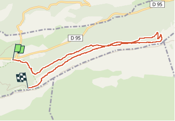
Trail Walking of 10.4 km to be discovered at Provence-Alpes-Côte d'Azur, Var, Plan-d'Aups-Sainte-Baume. This trail is proposed by Danielba .
Description
Randonnée aérienne. Passage 3b.chaines
Photos


Positioning
Country:
France
Region :
Provence-Alpes-Côte d'Azur
Department/Province :
Var
Municipality :
Plan-d'Aups-Sainte-Baume
Location:
Unknown
Start:(Dec)
Start:(UTM)
724104 ; 4801777 (31T) N.
Comments