


20230504 Beauvoir en Lyons

Childebert
User
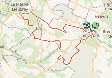

Length
20 km

Max alt
249 m

Uphill gradient
242 m
Km-Effort
24 km

Min alt
185 m

Downhill gradient
243 m
Boucle
Yes
Creation date :
2023-05-04 07:17:55.24
Updated on :
2023-05-04 18:32:53.93
5h21
Difficulty : Very difficult

FREE GPS app for hiking
 SityTrail
IGN / Geographical institutes
SityTrail Plus
The world is yours!
About
Trail Walking of 20 km to be discovered at Normandy, Seine-Maritime, Beauvoir-en-Lyons. This trail is proposed by Childebert.
Positioning
Country:
France
Region :
Normandy
Department/Province :
Seine-Maritime
Municipality :
Beauvoir-en-Lyons
Location:
Unknown
Start:(Dec)
Start:(UTM)
397594 ; 5484376 (31U) N.
Comments