


Flavignerot 20230504

cmike39
User
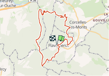

Length
19.6 km

Max alt
596 m

Uphill gradient
685 m
Km-Effort
29 km

Min alt
309 m

Downhill gradient
688 m
Boucle
Yes
Creation date :
2023-05-04 07:17:08.366
Updated on :
2023-05-04 13:58:37.787
5h09
Difficulty : Very difficult

FREE GPS app for hiking
 SityTrail
IGN / Geographical institutes
SityTrail Plus
The world is yours!
About
Trail Walking of 19.6 km to be discovered at Bourgogne-Franche-Comté, Côte-d'Or, Flavignerot. This trail is proposed by cmike39.
Positioning
Country:
France
Region :
Bourgogne-Franche-Comté
Department/Province :
Côte-d'Or
Municipality :
Flavignerot
Location:
Unknown
Start:(Dec)
Start:(UTM)
644944 ; 5237976 (31T) N.
Comments