


Soulce Cernay

taguette
User
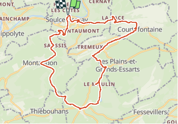

Length
23 km

Max alt
861 m

Uphill gradient
750 m
Km-Effort
33 km

Min alt
383 m

Downhill gradient
747 m
Boucle
Yes
Creation date :
2023-05-04 06:47:14.805
Updated on :
2023-05-04 16:21:53.059
6h19
Difficulty : Difficult

FREE GPS app for hiking
 SityTrail
IGN / Geographical institutes
SityTrail Plus
The world is yours!
About
Trail Walking of 23 km to be discovered at Bourgogne-Franche-Comté, Doubs, Soulce-Cernay. This trail is proposed by taguette.
Positioning
Country:
France
Region :
Bourgogne-Franche-Comté
Department/Province :
Doubs
Municipality :
Soulce-Cernay
Location:
Unknown
Start:(Dec)
Start:(UTM)
338184 ; 5243636 (32T) N.
Comments