


Sortie vtt du 23112014

fabwin
User GUIDE
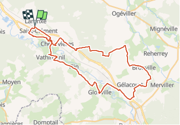

Length
41 km

Max alt
344 m

Uphill gradient
432 m
Km-Effort
47 km

Min alt
234 m

Downhill gradient
433 m
Boucle
Yes
Creation date :
2014-12-10 00:00:00.0
Updated on :
2014-12-10 00:00:00.0
3h06
Difficulty : Medium

FREE GPS app for hiking
 SityTrail
IGN / Geographical institutes
SityTrail Plus
The world is yours!
About
Trail Mountain bike of 41 km to be discovered at Grand Est, Meurthe-et-Moselle, Saint-Clément. This trail is proposed by fabwin.
Description
Chemin forestier, sous-bois, sentier, champs??!!!
De tout quoi!!
sauf des singles
Positioning
Country:
France
Region :
Grand Est
Department/Province :
Meurthe-et-Moselle
Municipality :
Saint-Clément
Location:
Unknown
Start:(Dec)
Start:(UTM)
323024 ; 5378546 (32U) N.
Comments