


Projet rando jour 3

psesjs
User
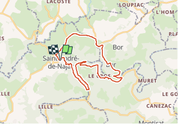

Length
16.1 km

Max alt
391 m

Uphill gradient
414 m
Km-Effort
22 km

Min alt
171 m

Downhill gradient
412 m
Boucle
Yes
Creation date :
2023-05-05 16:24:49.425
Updated on :
2023-05-05 16:24:53.86
1h30
Difficulty : Medium

FREE GPS app for hiking
 SityTrail
IGN / Geographical institutes
SityTrail Plus
The world is yours!
About
Trail Mountain bike of 16.1 km to be discovered at Occitania, Aveyron, Saint-André-de-Najac. This trail is proposed by psesjs.
Positioning
Country:
France
Region :
Occitania
Department/Province :
Aveyron
Municipality :
Saint-André-de-Najac
Location:
Unknown
Start:(Dec)
Start:(UTM)
423324 ; 4893440 (31T) N.
Comments