


2023-05-05_21h25m21_Rando_Pernes_1_trace_GPS

FLORENSAC
User
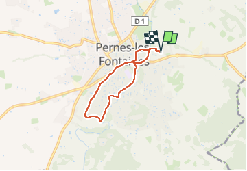

Length
5.2 km

Max alt
141 m

Uphill gradient
74 m
Km-Effort
6.2 km

Min alt
85 m

Downhill gradient
74 m
Boucle
Yes
Creation date :
2023-05-05 19:25:22.804
Updated on :
2023-05-05 19:25:24.559

FREE GPS app for hiking
 SityTrail
IGN / Geographical institutes
SityTrail Plus
The world is yours!
About
Trail of 5.2 km to be discovered at Provence-Alpes-Côte d'Azur, Vaucluse, Pernes-les-Fontaines. This trail is proposed by FLORENSAC.
Positioning
Country:
France
Region :
Provence-Alpes-Côte d'Azur
Department/Province :
Vaucluse
Municipality :
Pernes-les-Fontaines
Location:
Unknown
Start:(Dec)
Start:(UTM)
665845 ; 4873798 (31T) N.
Comments