Trail Other activity Laufenburg - y10_sulz - Photo

Optez pour le retour à la nature GUIDE+

© OpenStreetMap contributors
Length
Length
24 km
Max alt
Max alt
698 m
Uphill gradient
Uphill gradient
792 m
Km-Effort
Km-Effort  
34 km
Min alt
Min alt
302 m
Downhill gradient
Downhill gradient
792 m
Boucle
Boucle
Yes
Creation date :
2014-12-10 00:00:00.0
Updated on :
2014-12-10 00:00:00.0

(0 Reviews)

Other activity
Other activity
7h34
Difficulty : Unknown

Scan this QR Code to open this trail in the SityTrail application

FREE GPS app for hiking

Logo SityTrail SityTrail

IGN / Geographical institutes

Download SityTrail from the App Store Download SityTrail from Google Play

Logo SityTrail SityTrail Plus

The world is yours!

Download SityTrail from the App Store Download SityTrail from Google Play Download SityTrail on Huawei AppGallery

About

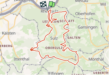
Trail Other activity of 24 km to be discovered at Aargau, Bezirk Laufenburg, Laufenburg. This trail is proposed by My Switzerland.

Elevation profile

Points of interest

Point of interest Laufenburg - Römerturm - Photo
My Switzerland
LAUFENBURG 
Point of interest Laufenburg - Nikolaus-Kapelle - Photo
My Switzerland
LAUFENBURG 
Point of interest Laufenburg - Amphibienweiher - Photo
My Switzerland
LAUFENBURG 
Point of interest Laufenburg - Lourdes-Grotte - Photo
My Switzerland
LAUFENBURG 
Point of interest Laufenburg - Sternwarte - Photo
My Switzerland
LAUFENBURG 
Point of interest Mönthal - Sennhütten - Photo
My Switzerland
MÖNTHAL 

Positioning

Country:
Switzerland
Region :
Aargau
Department/Province :
Bezirk Laufenburg
Municipality :
Laufenburg
Location:
Unknown
Start:(UTM)
431472 ; 5267347 (32T) N.


Close
My subscriptions